Archive for the ‘Uncategorized’ category

Proprietary formats and compatibility

August 31, 2008

Most of the questions I receive about map making have to do with proprietary software. That is, while some software seems “universal,” the truth is that files produced in one version are not compatible in a competing version. The success, therefore, is learning to minimize proprietary formats.

The obvious…

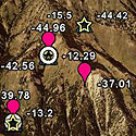
The simplest solution is to limit products that only save data in proprietary formats. The government-funded GPS satellite cluster is normally interpreted in a standardized, public format established by the US Coast Guard called “NMEA.” The GPS receiver will read the satellite information and transmit NMEA lines as ASCII strings. Most important is the summary line, or ‘fix data’ line, known as the GGA line. This line transmits the time, latitude, longitude, quality of fix, number of satellites, horizontal dilution of precision, altitude, and some other information. Because it is a simple ASCII line, it is easy to write software that seeks out this transmitted line and parses out the needed information. The most common commercial GPS receivers are produced by Garmin and Magellan. However, to keep customer’s cash, Garmin and Magellan use mapping software that relies on proprietary transmitted information so you cannot use other mapping software and you cannot use other brands of receivers. In summary, make sure your software can read NMEA format. In fairness, both Garmin and Magellan produce excellent products and more and more third party software can allow for Garmin and Magellan input. Read the fine print!

In a similar circumstance, it seems that every GIS program uses its own proprietary format. Rather than regurgitate a litany of acronyms, let’s just assume any product you use will have its own file format. While ESRI shape files (explained in another blog) are the most commonly shared, not all GIS programs allow for shape files. My advice: if you are not sure, save your data as a text (.txt) or comma-separated values (.csv) format. These are more universally read.

The subtle…

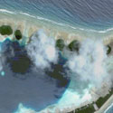
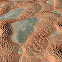
Have you ever been frustrated because you thought you were using a standard file format and the program would not read the file? For starters, have you received a .docx yet? I recently worked on an interesting problem with a colleague of mine that was a model for subtlety. Todd wanted to use SOLO Field on a Nomad Computer for collecting GIS data. His background map was a trimmed image from a much larger air photo. Both the original and trimmed map were saved in the standard geotiff (.tif) format which is read by SOLO Field. However, every time he loaded the map, the program would crash. We thought the problem was that the file was too big (~30 MB), but that wasn’t the case. It ended up that he used an ArcGIS product to trim the image and for some reason, the new image could not be read in a non-ESRI GIS. He went back and trimmed the original image in SOLO Office and everything worked smooth. Moral of the lesson: just because the file format is on the software list, doesn’t mean it will work.

ToughBook computers and GPS receivers

December 29, 2007

I am not a big fan of the integrated GPS that one can purchase as an option on the ToughBook for about $300. In my experience, the GPS does not perform as well as cheaper add-on units. But, I will lay out my thoughts and you can make the call.

Benefits

The obvious benefit is that you have an integrated GPS so you will never lose it, forget to bring it to the field, or neglect to charge the battery. Also, there are no USB cables to get tangled in. If these are issues for you, and the extra one to two hundred dollars isn’t an impediment, than buy the integrated GPS. Why not? Regardless of the company’s claims, I would not rate this GPS for better than + / -15 meters accuracy. Is that important? For reference, remember that the standard USGS 7.5’ quadrangle maps that form the basis for most off-the-shelf high resolution software are at a scale of 1:24,000. Since a dot on that map is about 1 mm across, the dot represents 24,000 mm on the ground, or 24 meters. That is about the resolution of the integrated GPS. So, no problem. But, if you want to display your locations on a higher resolution map, it will be a problem.

Drawbacks

Beside the coarse accuracy, the biggest drawback is the price. It costs about $300 to add a GPS onto a computer from the factory. In comparison, I use a USB-driven device (GlobalSat) that costs about $70. I have been very, very pleased with the accuracy, quick start-up, and ruggedness of this unit. I have also used a Bluetooth-enabled device (GlobalSat) that costs about $115. Both of these options also allow for using the device with another computer—including a Macintosh or PDA! Folks who have read my other blogs will know I am a big fan of modularity. The GlobalSat units, in my testing, get closer to 3-5 meters of accuracy, or a dot on a 1:10,000 scale map.

For my ToughBook mapping, I use a USB-driven receiver and bundle the cord and tie it to the handle of the tablet. As a geologist, I have worked in many terrains with this set-up and have never felt burdened or been trapped on bushes. However, if I was to buy a ToughBook on a grant and could spare the few extra hundred dollars in the budget, I would likely get the GPS for when I was doing coarse mapping, or forgot the USB GPS, or forgot to recharge the Bluetooth GPS…

Figuring out the GPS COM port on a ToughBook PC

December 27, 2007

I receive quite a few phone calls each year from ToughBook owners trying to figure out how to use the GPS receiver. A ToughBook with integrated GPS from the factory comes with a default COM port dedicated to the GPS, but which one? You need to know this COM port for using software, but also, in the event of a malfunction, you will need to test the GPS to make sure the defaults from the factory haven’t changed. To find out, the best route is to use the HyperTerminal program.

To get to HyperTerminal, start with the START button in the lower left corner:

START > All Programs > ACCESSORIES > Communications > HyperTerminal

Under “Connection Description” give any name to the New Connection, it won’t matter. The icon also doesn’t matter. In the next box, under “Connect Using” scroll down to COM 1. The properties screen will appear. Change to the following if set differently:

Bits per second: 9600; Data bits: 8; Parity: None; Stop bits: 1f; Flow control: None

Click OK.

On the main HyperTerminal screen, you should see a string of characters which are the NMEA sentences (e.g., $GPGGA, $GPGSA, etc., followed by comma-separated values). If not, chose “Disconnect” from the toolbar, then reconnect and start over but chose COM 2 this time. Keep working through the COM ports until one works. Record this COM port as it should not change. If you have the COM port correct in the software, but it still is not connecting to the GPS, make sure the Baud rate hasn’t changed. I have seen that happen and most times the software and GPS are not communicating, it is a mismatched Baud rate; the rest of the time, the GPS isn’t connected.

I finally entered the Blog world….

September 30, 2007

…and I don’t have a clue what I am doing! If you feel similarly, you are in the right spot. I started this blot on the advice of my friends who thought there was a place for me in the murky ethers of the Internet. In short, I am a professor of Geology who uses field computers, GPS, and GIS in my research, but I was never formerly trained in these products. (I am writing this first blog from a motel room on the northern California coast, getting ready for field work tomorrow at the beach.) I have spent a fair amount of time sorting out how things work and wading through the immense literature. In my role as tech adviser for Walcott Scientific, folks have responded enthusiastically to my clear explanations and helpful advice. I think this success is due to my teaching large undergraduate classes (which I love to do!). Well, it seemed natural to turn those answers into a blog to reach out to more folks. If you are bugged by a problem that doesn’t make sense, send me a note, and I will try to sort it out and post it on the blog. Enjoy!

2007_feb-045.jpg